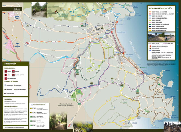
Xàbia is beach and mountain. they are well known its beaches, coves and its hiking routes that run along the coast or the routes through the Montgó Natural Park, but what other beauties run through the municipal area?

In this report we present the other side of Xàbia, that of rural and agricultural Xàbia. Through 10 routes, of all levels of difficulty, you will be able to reach the places of tourist interest while cycling along small rural roads and observe the history of this town.
- 1.
- 1.1.
- 1.2.
- 2.
- 2.1.
- 2.2.
- 3.
- 3.1.
- 3.2.
- 4.
- 4.1.
- 4.2.
- 5.
- 5.1.
- 5.2.
- 6.
- 6.1.
- 6.2.
- 7.
- 7.1.
- 7.2.
- 8.
- 8.1.
- 8.2.
- 9.
- 9.1.
- 9.2.
- 10.
- 10.1.
- 10.2.
- 11.
- 12.
Route Volta al Montgó
In order not to miss a detail of the Montgó massif and to know it in its 360º, we present the route that surrounds the Natural Park Montgó, crossing an agricultural area of great beauty and environmental value. At the stroke of a pedal you will be able to see all the faces of this emblematic mountain.
This route has an easy layout, without large slopes, making it accessible to a wide range of users.

Itinerary
The route starts from the Port of Xàbia to finish in the Port of Dénia from where you can return either by bike or by boat, contemplating the impressive cliffs of the Cap de Sant Antoni.

The route runs along roads little traveled, which allow us to contemplate the rural and agricultural tradition of towns such as Xàbia, Jesús Pobre and La Xara.
Features
- Departure from: Port of Xàbia.
- Check-in: Port of Denia.
- Distance: 26,5 km from port to port.
- Effective time: 3 hours by bike + 45 minutes by boat.
- Accumulated elevation gain:215 meters
- GPS:Xàbia Turisme Wikiloc route.
- Difficulty level: Low
- Signaling: Orange

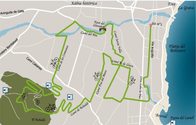
Rebaldí Route
The Rebaldí forest route is a short route that enters a dense pine forest located in l'Alt de Capsades. This area is a hunting ground and although the paths are close to the highway and the houses, they do not present any danger, it is advisable not to leave them during the hunting season.
The route has a lot of unevenness, so the person or people interested in doing it should be in good shape. It is important to have several gears on the bike to climb the 2 kilometers of Camí del Rebaldí.

Itinerary
Once in the upper part of Rebaldí, we will enter the paths to the forest, one of the most fun sections. Along the route we find three points where we can stop to contemplate some splendid views of the Montgó and the bay of Xàbia, from where on clear days you can even see the island of Ibiza.
Features
- departure and arrival: Augusta Avenue (IES La Mar-formerly IES Nº1).
- Distance: 18 km round trip.
- Effective time: 1 hour 45 minutes.
- Accumulated elevation gain: 97 meters.
- GPS: Xàbia Turisme Wikiloc route.
- Difficulty level: Low.
- Signaling: green color.
Tarraula Route
This circular route runs between agricultural roads and traditional paths, almost all paved and predominantly flat. The route crosses the term of Xàbia diagonally and then approaches the edge of the term of El Poble Nou de Benitatxell. The excursion circulates among pine forests and fields of vineyards, arriving at Tossal Gros, and returning to the starting point along the banks of the Gorgos River.
Itinerary
The fact of having three clearly defined sections, and in increasing order of difficulty, makes it a suitable route for any level.
The greatest difficulty lies in a couple of slopes of only 100 meters (on Lago Tana and Giovanni Bocaccio streets), a narrow path that passes through a forest (Pío Baroja street), and the climb up Camí de Tarraula (1 km ) in addition to the steep descent to Camí Cabanes.
People not used to riding a bike and small children have the option of going to Parque de las Laderas and returning along the same path (12 km).
Features
- departure and arrival: Augusta Avenue (IES La Mar-formerly IES Nº1).
- Distance: 18,7 km round trip.
- Effective time: 2 hours 15 minutes.
- Accumulated elevation gain: 153 meters
- GPS: route in Wikiloc of Xàbia Turisme
- Difficulty level:
- To Parque Las Laderas: Low.
- Up to Pío Baroja: Low/Medium.
- Full route: Medium. - Signaling: pink colour.

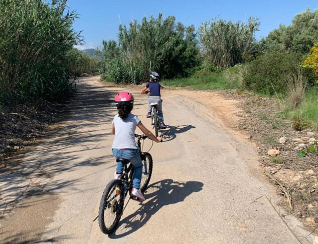
Port-Cala Blanca Family Route
One of the best routes and aimed at all levels and ages is the one that runs along the coast of Xàbia. This route, which leads from the fishing port to the Cala Blanca, is of little difficulty and flat profile; which makes it an ideal route to enjoy a pleasant family outing.

The route runs through the entire bay of Xàbia, from the port, sheltered by Cabo de San Antonio, to the Cala Blanca o Caleta, set of three small coves.
Throughout the route you can see the fishing boats and their tools, 'Les Tosqueres', quarries that since the Middle Ages have provided Xàbia with stone for the construction of its buildings, as well as constructions from Roman times such as 'Els Banys de la Reina' (Queen's Baths) and 'Drought of the Ferris wheel'. Thus, trades, tradition and landscape are combined in a route suitable for all ages.
Itinerary
The route begins at Paseo del Puerto until the end of the breakwater, returning along it to take the bike path along the first Muntanyar, which leads to Playa del Arenal. Then continue along Calle Atenas avoiding the main road to reach Cala Blanca. Halfway there is the corner of the Séquia de la Nòria.
Once there you can visit the Viewpoint of the Caletes going up through some stairs that are located at the foot of the first cove. On the way back, after Playa del Arenal, take the bike path that runs along the Canal de la Fontana and that leads along Avenida Augusta to the starting point of the route.

Features
- departure and arrival: End of the Paseo del Puerto-Lonja.
- Distance: 11,42 km round trip.
- Effective time: 1 hour 10 minutes.
- Accumulated elevation gain: 10 meters.
- GPS:Xàbia Turisme Wikiloc route.
- Difficulty level: Low.
- Signaling: Red color.

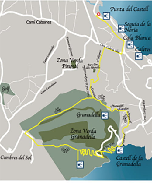
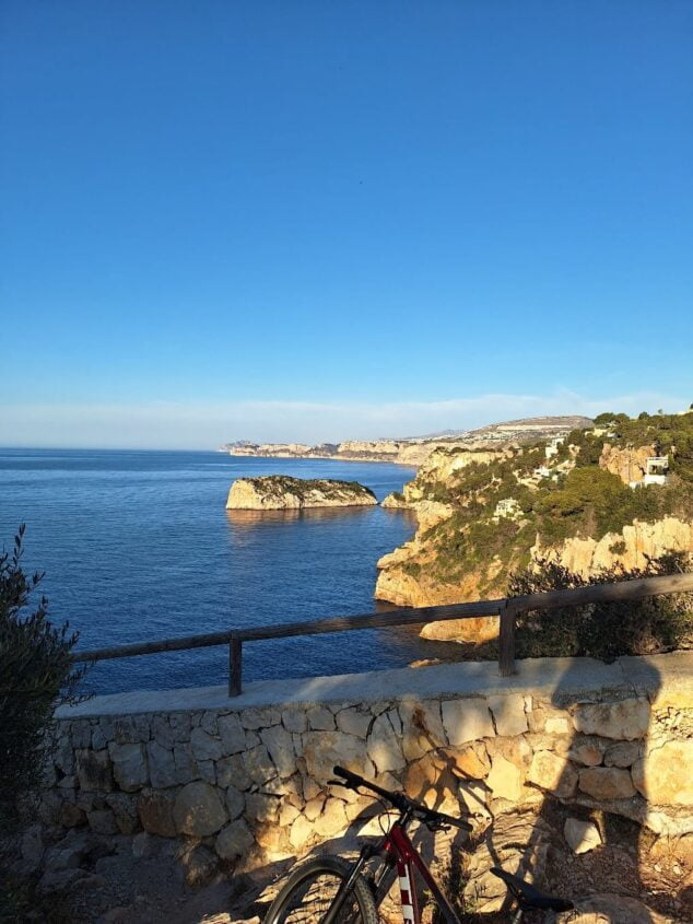
Granadella Route
Although the granadella It is known for its cove, this route will surprise users by entering an unknown area and beautiful landscapes of Monte Público de la Granadella. Despite the fact that the first two kilometers of the route are through an urban area, this route runs mostly through the forest area, between pine forests and Mediterranean scrub.

On the way you can visit a total of four viewpoints where you can contemplate the beauty and corners of Xàbia, two green areas, a public forest, a cove and two municipalities.
Itinerary
The path through the park itself is not difficult, as it is a forest track, but along its 21 kilometres, it does present some demands, especially in the 500-meter section of Camí Vell de la Granadella until reaching the Vigilance tower. It is recommended to stop to rest and have lunch in Cala de la Granadella.

The return, by the road from the cove, is short, being able to stop to contemplate the spectacular view from the Viewpoint of the Castell de la Granadella.
Features
- departure and arrival: Arenal-Canal de la Fontana car park.
- Distance: 23,7 km round trip.
- Effective time: 3 hours 45 minutes.
- Accumulated elevation gain: 551,1 meters.
- GPS:Xàbia Turisme Wikiloc route.
- Difficulty level: High.
- Signaling: Yellow color.
Les Planes Route
This route proposes a bike ride through the Montgó Natural Park. A nice 18 kilometer loop between pine trees and scrub with some spectacular views of the bay of Xàbia. the area of Les Planes, as its name indicates, is relatively flat, but to reach it you have to climb up to 200 meters of altitude in just 2 kilometers.
For those who prefer to avoid this section, they can choose to start the route from the Les Planes Recreational Area, which is a quiet area, ideal for walking, surrounded by nature and always a few degrees cooler than at sea level.
Itinerary
The departure begins from the Port and ascends to the Hotel Costamar, to reach the Cuesta de San Antonio. With shadows and several sections of considerable slope, to which it is advisable to do it on foot, you will arrive at Les Planes, where you will visit the Viewpoint of the Cabo de San Antonio.
The route runs along a gravel path, among pine trees and with views of the sea, to then cross the Dénia road to Plana Justa, where a circular route will be followed, and beautiful views can be contemplated.
For the return it goes towards Les Planes although first it will stop to visit Els Molins (old windmills). Finally we take the way back through Cuesta de San Antonio and arriving again at the starting point, the port of Xàbia.

Features
- departure and arrival: End of the Paseo del Puerto-Lonja.
- Distance: 18,3 km roundtrip-complete route and 11,5 km from Les Planes (Recreational Area).
- Effective time: 3 hours.
- Accumulated elevation gain: 288 meters.
- GPS: Xàbia Turisme Wikiloc route.
- Difficulty level: Medium/High (full route)- Medium from Les Planes.
- Signaling: light blue.

Route Viewpoints of Xàbia
The 15 viewpoints of Xàbia They are another great tourist attraction. Contemplating the different corners, beaches, coves and landscape from these places is something surprising. On this occasion, it is proposed to reach these points with a bike ride, enjoying at the same time the beauty of the route for its flora and its views of Cap Prim, Cap Negre, Cabo de la Nao, El Montgó, La Falzia, Cabo de San Antonio and the Granadella Forest Park.
The route runs mainly among pine trees, which makes it ideal for hot days. On this tour, 13 of the 15 viewpoints will be visited.
Itinerary
This route, of almost 30 kilometres, starts from Playa del Arenal and continues along the Cala Blanca towards Portitxol, until reaching the La Guardia plateau. It is not a particularly hard route, but it does have some ramps, especially in the first part, which will surely force us to go on foot.
The route presents a leg-breaking profile, which, although it is not particularly difficult, you must be in shape so as not to end up too fatigued. The route takes you through an area of urbanizations populated with pine trees, so the route is pleasant and fresh.
Features
- Departure from: Arenal-Canal de la Fontana car park.
- Check-in: Punta del Arenal Viewpoint.
- Distance: 27,2 km roundtrip-complete route and 11,5 km from Les Planes (Recreational Area).
- Effective time: 3 hours.
- Accumulated elevation gain: 514 meters.
- GPS:Xàbia Turisme Wikiloc route.
- Difficulty level: Medium/High.
- Signaling: olive green.

Parks Route Xàbia
In this easy 21-kilometre tour, you will get to know a part of the large number of green areas and parks that Xàbia has and that are unknown. The route runs mainly along small paved streets with some slopes.
Itinerary
The route runs through an urbanized area, but the number of small paths and corners that are still lost among the chalets is surprising. The route passes through a total of parks: Cap Martí, Pou dels Abanells, Pinosol, Las Laderas and Rafalet, and ends in the park that borders the river, in front of the La Mar Institute (formerly IES No. 1).
Features
- departure and arrival: Augusta Avenue (IES La Mar-formerly IES Nº1).
- Distance: 20,6 km round trip.
- Effective time: 3 hours 10 minutes.
- Accumulated elevation gain: 233 meters.
- GPS:Xàbia Turisme Wikiloc route.
- Difficulty level: Medium.
- Signaling: lilac.

Tossal Gros Route
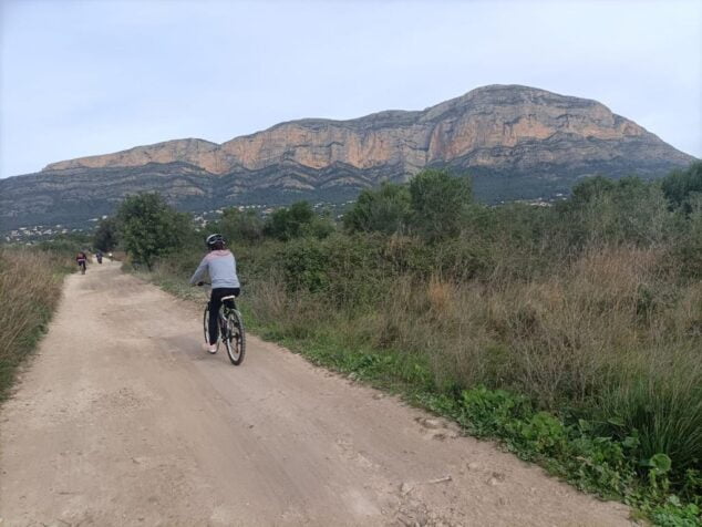
This is the hardest route of all those that have been commented, but it is worth it for the views. Once in the highest area, not only can you see the Montgó, Cabo de San Antonio and Puig Llorença, as well as Bérnia and the Moraira coast, but on clear days you can see the island of Ibiza and even Mallorca. They are just over 20 kilometers with 3,5 km of continuous ascent, so it is recommended to be in good shape, or at least accustomed to riding a bike.
Itinerary
The difficulty of this route begins after the Golf Club, where we find the toughest ascent section that leads to the Miradores area. As a reward, the spectacular views and a descent of almost 4 kilometers that ends up crossing a beautiful and small stretch of forest in the Rafalet area.
Features
- departure and arrival: Augusta Avenue (IES La Mar-formerly IES Nº1).
- Distance: 21,2 km round trip.
- Effective time: 2 hours 30 minutes.
- Accumulated elevation gain: 346 meters.
- GPS:Xàbia Turisme Wikiloc route.
- Difficulty level: High.
- Signaling: dark blue colour.

Forest Route of Capsades
This route is ideal for those who are looking for some fun and who love mountain biking. It is a short route that takes the cyclist to the south side of the Capsades forest. The proposed route, although 18,6 kilometres, is somewhat difficult, due to the slope of the Camí de la Sabatera, a stretch of stones through which you have to carry the bike in your arms and some narrow and somewhat technical paths through the forest.
Itinerary
After the first flat kilometers through El Plà and a steep climb up Camí de la Sabatera, you enter the wooded area of Capsades, where there are several paths that provide fun routes. Afterwards, the Rafalet urbanization is crossed, and the route leads to the starting point bordering the river.
Features
- departure and arrival: Augusta Avenue (IES La Mar-formerly IES Nº1).
- Distance: 18,6 km round trip.
- Effective time: 2 hours.
- Accumulated elevation gain: 102 meters.
- Difficulty level: High.
- GPS: Xàbia Turisme Wikiloc route.
- Signaling: Green color.

Bicycle Rental
For visitors and tourists who want to do one or more of these activities and do not have a bicycle during the holiday period or any citizen who wants to get to know Xàbia from another point of view, they can rent one through some of the rental companies bicycles that are in Xàbia.
- Xabia's Bike: Located in the port of Xàbia. Lepanto avenue.
Bibliography
- Information provided by Turisme Xàbia


They announce possible activities to do, they do not force you to do them in the next ten days from 12.00:18.00 to XNUMX:XNUMX with the children.
Then each one, within their responsibility and possibilities, will do what they should, can or want, it would be missing more!
This is a supposed article but it is actually surreptitious advertising. The bike rental company is at the end. And there would be more! take away someone's right to suffer a good heat stroke... that's never the freedom to always choose.
With this heat, do they announce bike routes? irresponsible. And on top of that "for the whole family"...