One way to get to know Xàbia is through its panoramic images. From different points of the municipality you can see spectacular views of its landscape, its beaches and its coves. The route of the 15 viewpoints is one of the main attractions of the town. Located between the 25 km of coastline, these panoramic observation points are easily accessible.
Next you have an index with all the points that we are going to deal with.
The visit to each of the viewpoints can be done both in any type of vehicle or on foot, the latter option being the most recommended for the viewpoints that are nearby (not for the entire route) and thus enjoy the environment and nature. .
To follow a linear and orderly itinerary, in this section we name you from north to south, where the viewpoints are located and what their main characteristics are:
Cap de Sant Antoni
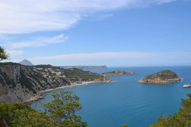
From here you can see a large part of the bay of Xàbia. From this balcony overlooking the Mediterranean, we can see the seaside neighborhood of Duanes de la Mar, as well as its marina. In this viewpoint there is a lighthouse, which formerly turned out to be a watchtower. This lighthouse is located on a cliff where there are two plant micro-reserves, one on its north cliff and the other in l'Illot de la Mona, at the foot of the Cape San Antonio.
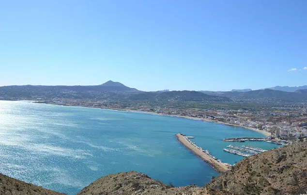
Cabo de San Antonio is located between the municipalities of Jávea and Dénia and is part of the Natural Park Montgó. On the same cape there is a lighthouse, still in operation, of the second order, which dates from 1855 when it was lit for the first time. The height of the lighthouse above sea level is 175 meters.
Note that from this viewpoint you can see the island of Ibiza when the day is very clear.
For more information on viewpoint of Cap de Sant Antoni on request this link.
Els Molins
About 20 minutes on foot from the Mirador del Cap de Sant Antoni. The mills in the area Les plans they are another emblematic scenario that cannot be missed. The first construction was in the fourteenth century. Ten other towers followed years later. Currently, the remains of some of these old mills are without blades or covers, but they can be observed and discover the unique place they occupy.
From this viewpoint, in addition to contemplating the buildings, you have a great view of Xàbia, of the entire bay, as well as Cabo San Antonio and the urban area and its beaches.
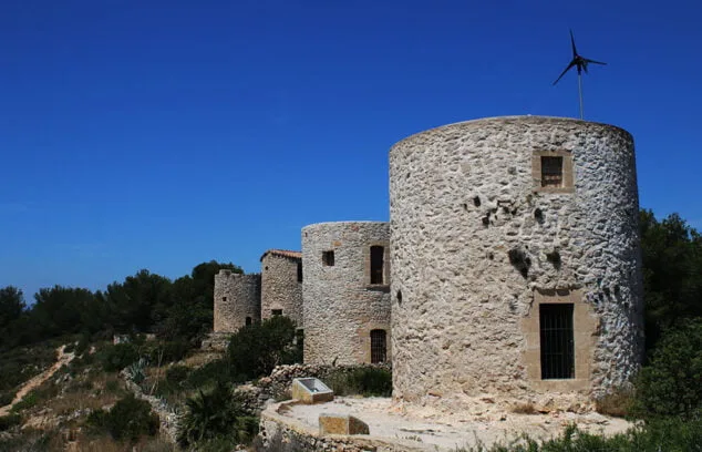
Today, these mills are in disuse. Its function was to grind wheat. There are a total of 11 windmills characterized by their cylindrical shape, about 7 meters high and a diameter of more than 6 meters. The interior has two floors. The ground floor was used as a warehouse and the upper floor, supported by a tosca ashlar vault of 1/4 sphere, housed robust holm oak wood mechanisms that moved the heavy stone millstones and supported the blades attached to a horizontal axis. All this disappeared at the end of the XNUMXth century. Of this large set, three are municipal property and their restoration and recovery is planned.
For more information about the natural area of Els Molins you can consult this report.
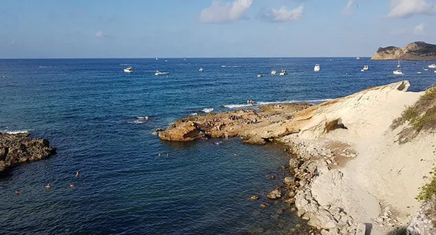
Punta de l'Arenal
From here we see the Playa del Arenal, the only sandy beach in the town. From the viewpoint, located in the southern part of the beach, you can see a complete panoramic view with the Montgó in the background.
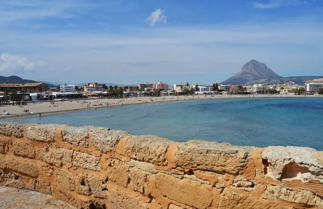
In this area there is a large archaeological site, from the XNUMXst century BC, known as The queen's baths And which housed a Roman fish farm. This settlement is located in the present Ministre Creek, Just behind the Parador Nacional.
This balcony can be accessed on foot along the beach itself or by car following the road. The Montgó, the Cabo de San Antonio and the Arenal beach are the magnificent views that can be seen.
For more details on the Arenal Beach visit in this article.
Sequia de la Nòria
In this fourth viewpoint you can see a large channel cut and excavated on the toscar, which was used during Roman times to allow the entry of seawater, forming an area of salt flats known as the Saladar.
Over the centuries, and in medieval times, the noria was incorporated, a mechanism with a large vertical wooden wheel moved by an animal.
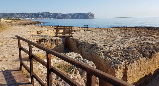
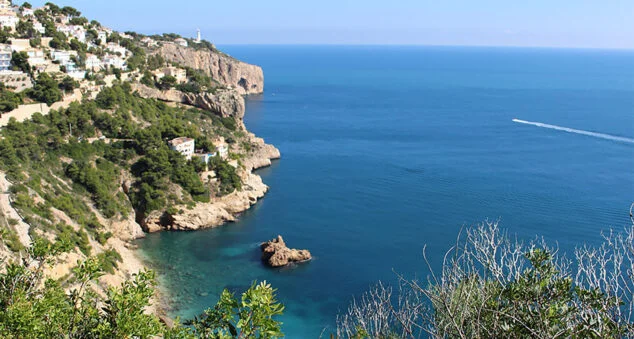
The Séquia de la Nòria is located in the area known as Segundo Montañar or Montañar II. It forms the coastline of Xàbia before reaching the Cala Blanca o Caleta. From this emblematic place you can contemplate the sea, Cabo San Antonio and Cap Sant Martí or also known as Cap Prim.
The uniqueness of this area of Xàbia and identity sign is the rough stone found. A stone easy to carve that has been used for construction, since most of the arches of the houses of before and type of stone and hence the well-known 'Tosca de Xàbia'.
Learn more about the Séquia de la Nòria at this link.
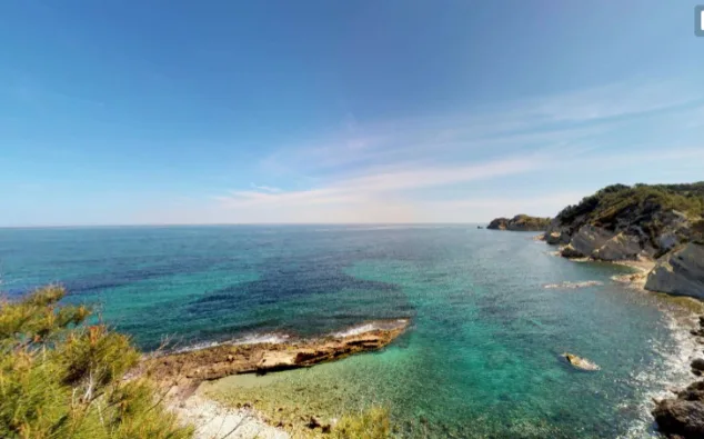
Cala Blanca or Caleta
This is one of the coves most frequented by tourists but its history is given by the old fishing activity. From land, the sea was embraced with a large net, which was also held by boats. Man thus created Trap, A deadly trap especially for tunas.
La Caleta or Cala Blanca, a rock formation, is characterized by its clear turquoise blue water and the whitish color of its rocks, hence its name.
From the bottom we can see the clear waters of the cove. From this cove there is access to the area of Les Caletes (we discuss below). In addition, its holed rock gives access to the other cove and supports the stairs that give access to the viewpoint in this area.
Check the characteristics of Cala Blanca in this report.
Caletes
From this viewpoint you can see, practically, the whole coast. On one side you can see the area of the two Montanyars and Cap de Sant Antoni And on the other the Cap Prim.
This viewpoint is located at the top of what is also known as the second Caleta. To access this area of Xàbia or the viewpoint, it can be done either by car or on foot, accessing the path from Cala Blanca or Caleta.
On foot you have to cross through the holes dug out of the rock, so we leave the viewpoint on the upper right and walk to the beach.
On the other hand, you can also access the viewpoint by following the road towards Cabo la Nao and following the indication of the viewpoint that we will find on the left.
Know all the details of Les Caletes Viewpoint en this article.
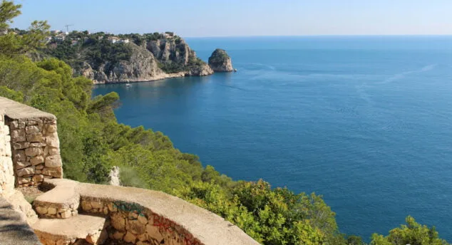
Creu del Portitxol and L'illa
On this occasion we join two viewpoints of the route in a single point. These two balconies to the sea are, without a doubt, one of the main attractions of Xàbia. Two different scenarios, but from where you can see a unique panorama.
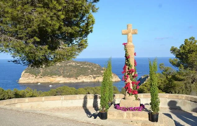
We continue from the previous viewpoint along the Cabo la Nao road heading south and arrive at the Creu del Portitxol viewpoint from where we can see l'illa del Portitxol. An islet that reaches 300 meters in diameter, which was once inhabited and where some burials have been discovered.
Currently, this island is considered one of the most representative and is in the process of becoming a Site of Cultural Interest.
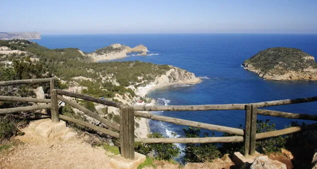
La Falzia
It is located at 150 meters from the Cala Portitxol or Cala de la Barraca, which is at our feet. From this point, a spectacular drawing of the entire coastline is offered. In this viewpoint you can see a panoramic view from the Cap de Sant Antoni and Cap Prim to the imposing image of Cap Negre. Unique image that you will not get tired of seeing.
All the information of the Mirador de La Falzia you can consult it here.
Cap Negre
Located in a cliff area, in this viewpoint you can see the paths used by fishermen to go down to the sea. The best image from this balcony, nestled in a beautiful wooded area, is to observe the coastline and the capes of Xàbia.
From the viewpoint of Cap Negre, located near the Cap de la Nao, you can perfectly see practically the entire coastline of Xàbia: Cap Prim, the Cabo de San Antonio, the Montgó, l'illa del Portitxol and some of the coves of Xàbia.
It is accessed by car until the arrival of a path that takes you into the interior of nature where you can enjoy the magnificent scenery.
For more information you can consult this article.
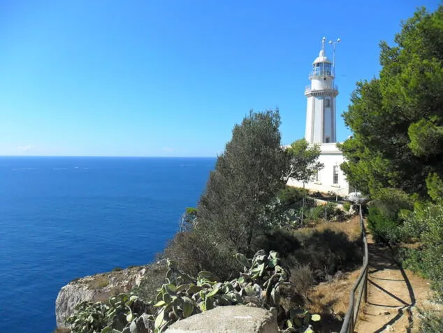
Cap de la Nau
This cape is the closest peninsular point to the island of Ibiza, which is 85 kilometers away by sea. The Cap de la Nau is the border between the gulfs of Valencia and Alicante, so it is the point that marks the end of the Xabiero coastline.
At the foot of the cape you can visit the well-known Cova dels Orguens, a natural cavity. At its top, at the top of the cliff, we find a lighthouse.
The octagonal lighthouse has a height of 20 meters and is located about 122 meters above sea level. Currently, this lighthouse is in operation and its light reaches a distance of 23 miles.
Les Pesqueres
El viewpoint of Les Pesqueres brings together a small universe of place names created from the fishing activities carried out by the men of Xàbia and the neighboring towns. Its name comes from when the neighbors used to settle at this point to fish.
Without a doubt, this cliff marks a great story from the past. Despite the obvious difficulties, easily perceptible from the viewpoint, the men installed the hurdles on the rocks to act as a base and they could fish.
Al viewpoint of Les Pesqueres, which can be reached directly by car, is reached by reaching Cabo de la Nao itself and entering between Pau Casals and Juan Carlos Pau streets to reach the same viewpoint that offers views of the lighthouse of this cape and l'illa del Discoverer.
Know all the details in this report.
Ambolo viewpoint
Cala Ambolo, is a cove known as nudist, which is currently closed to the public due to landslides. Although it cannot be accessed from the beach, we can see the cove and the landscape through its Ambolo viewpoint.
To get to it, following the Cabo la Nao road and turning off a few meters as indicated by the viewpoint route signs, we approach Torre Ambolo street, where this observatory is located. From this place you can see the neighboring town of Moraira and the previous Cap de la Nau.
More information in this link.
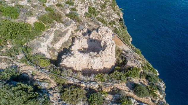
Castell Granadella
El viewpoint of the Castell de la Granadella It is located in the place of La granadella. Its well-known and emblematic cove is located in a large natural space of more than 600 hectares.
This area is marked by the ravines that end at the end of its route forming the cove. In its history it keeps the construction of the Castell Granadella. A small fortification built in the XNUMXth century, with the outer wall lined with rough stone, and which was occupied by a garrison of three men and two bronze cannons.
Consult more details of this viewpoint in this article. You can also learn about the history and characteristics of the Castle at this report.
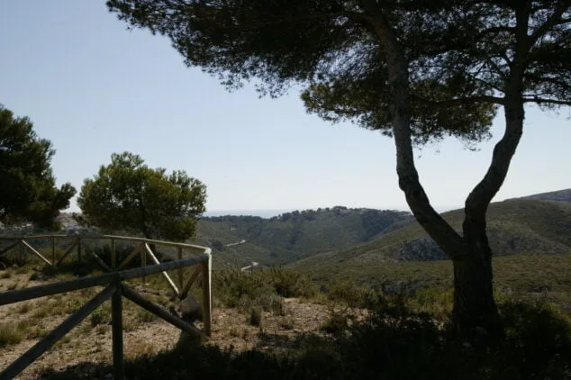
Granadella viewpoint
Located inside the Granadella forest park, this viewpoint offers magnificent views of the mountain on which it is located. It is located between Puig de la Llorença (El Poble Nou de Benitatxell) and Cabo de la Nao (limit of the Xàbia coastline).
It is located at an altitude of 142 meters, away from the sea, but still offers a special charm like the rest of the viewpoints on the route.
This balcony to nature allows you to see the interior of one of the best places. The ravines, the fauna and the great botanical wealth that this corner gives off make it visited by many tourists.


Very good article Veronica. Thank you very much
regards