The Les Pesqueres viewpoint is one of the quietest and least traveled viewpoints in Xàbia. It is located between the Cabo de la Nao and the Ambolo viewpoint, and is part of the Route Jávea Viewpoints.

Next you have an index with all the points that we are going to deal with.
- 1.
- 2.
- 2.1.
- 3.
- 3.1.
- 4.
History
The name 'Les Pesqueres' is due to the fact that in ancient times many fishermen used to hang down from the walls of this cliff to fish. The story tells that they did it on the rocks or on hurdles with the traditional methods of cane and fitora (trident). This activity generated rope and cane structures called fisheries (In Valencia).
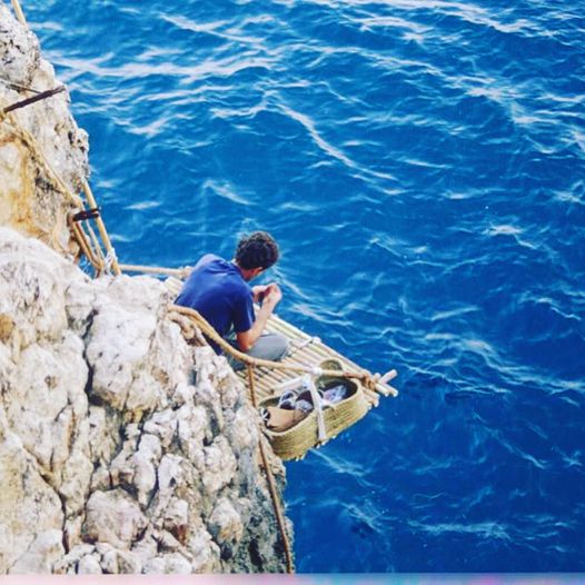
This was a very risky form of fishing that was used by fishermen from the neighboring town of El Poble Nou de Benitatxell. Nowadays, this method is only practiced by relatives of the legendary fishermen.
Where is the Mirador de Les Pesqueres
This viewpoint is located on Calle Joaquín Turina, between Cabo de la Nao (to the north) and the Ambolo viewpoint (to the south).

Address
To get to it, you have to drive along the Portitxol road and turn off at the 'La Siesta' Urbanisation. Even so, your way is clearly indicated through the signs.
https://www.google.com/maps/d/edit?mid=13g06W5USP97RgiIGjiLLcAEWRI0Sp78&usp=sharing
If we base ourselves on the map of the route of viewpoints, this viewpoint corresponds to point 12 of the itinerary. Access can be made with any vehicle, but once we reach the viewpoint, we must follow the short path on foot to the balcony overlooking the bay, since a chain prevents access.

The views
The viewpoint is at the top of a cliff, and on clear days you can see the coast of Teulada-Moraira, Poble Nou de Benitatxell, and in the background the Peñón de Ifach de Calpe. In the same viewpoint you will find an area with benches to rest and observe the wonderful views of the sea and nature.
Looking out, to our left (to the north) we can see Cabo de la Nao with its white lighthouse.

If instead we look to the right (towards the south), we see the Island of the Discoverer.

Vegetation
In this area of the coast we contemplate a steep geology, with a climate and relief similar to that of the Balearic Islands. Their proximity causes the same type of flora to be found in the area of Les Pesqueres, the so-called riparian vegetation.
This vegetation is characterized by the growth of species adapted to the salinity of the sea, to the scarcity or total lack of soil (because they grow on the rock) and to the force of the wind.

Information panel text:
The steep and dangerous cliffs of this coastline could never dissuade the men of Xàbia and neighboring towns, especially those of Poble Nou de Benitatxell, from hanging down these rocks and fishing with the traditional rod and 'fitora' (trident) arts. , the rich species that these deep and clean bottoms produce. This fishing activity has generated, in addition to some original structures of ropes, hurdles and other elements known as "pesqueres", a rich and diverse toponymy that allows identifying and naming each of the varied geographical features of the coast.
Everything in this territory reminds us of the proximity of the Pitiusas Islands: the geology, the relief, the vegetation and the climate. Rupicolous vegetation grows through the cracks and crevices of the rocks, among which endemic species (Hippocrepis valentina, Escabiosa Saxatilis...) are frequent, which show the floristic relationships related to the southern world and the Balearic Islands.
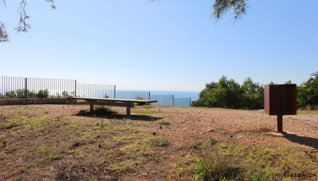
Photo Gallery
-
 Walking area in the viewpoint of Les Pesqueres

-
Railing along the viewpoint of Les Pesqueres

-
Views through the railing at the viewpoint of Les Pesqueres

-
Views to the south from the viewpoint of Les Pesqueres

-
Cliff and reflection of the sun in the viewpoint of Les Pesqueres

-
If you look down, the cliff is populated with native vegetation

-
Homes very close to the viewpoint of Les Pesqueres

-
Information panel at the bottom of the access road to the viewpoint of Les Pesqueres

-
Detail of the informative panel of Les Pesqueres

-
Map of the viewpoints route, where you can find Les Pesqueres


