El Natural Park Montgó contemplate different hiking routes. The route to the top of Montgó from Jesús Pobre, is one of the longest (if we compare it with the route that starts from the Dénia Shooting Range). The maximum height that is reached is 750 meters and the minimum is 126 meters.

Next you have an index with all the points that we are going to deal with.
- 1.
- 2.
Technical data
La distance of this route is a little more than 6 kilometers, specifically 6270 meters. The duration estimated is 3 hours 45 minutes and the difficulty of the route is considered high. The cumulative elevation gain is 746 meters.
Route layout
El tour as shown by Wikiloc starts on the way Media, in Jesús Pobre (Minor Local Entity within the municipality of Dénia). This itinerary starts from the CV-735, the Xàbia-Dénia road: there begins a cobbled path that passes next to a fire-fighting water tank. In about 500 meters it becomes a heavily eroded forest track where the slope begins to increase. From here, the route enters a narrow mountain path.
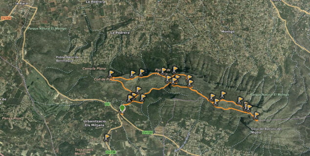
Following the path, we find the Iberian wall from the XNUMXnd century BC, which protected the town of La Penya de L'Àguila. When we leave these archaeological remains behind, we come to the crossroads with the orange route: the one that joins the Camí de la Colònia (Dénia) with the top, and which is more difficult but shorter.
We continue the path along the entire Montgó hill, and we arrive at the geodesic vertex that indicates the top, at 753 meters above sea level.
Regarding what we can see along the way, before we start to climb the narrowest path, when we are about 350 meters above sea level, the views of Jesús Pobre and everything that Montgó collects to the south are beautiful. Once at the top of Montgó, at 752 meters above sea level, you find yourself in an excellent viewpoint of the Marina Alta region.

During the tour, once we enter the ravine of l'Hedra and run through the upper part of the Montgó, we can choose the path that also leads us to the cross of Denia, on the way out or on the way back. In this section between the Cruz de Denia and the summit, we cross the access pass to the l'Emboixar ravine, one of the micro-reserves of flora in the area.
From the Cap Gros del Montgó we have a good view of the Marina Alta, with the Cape San Antonio To the East. On the way back, when we reach the crossing of the l'Hedra ravine and continue along the path that runs through the mountain range, heading west, we will pass by the old walls of the Iberian town of La Penya de l'Àguila.


